
Rusinowo beach drone, Sep 14, 2026 - Russian Gerbera
A suspected Russian Gerbera drone drifted ashore on a Baltic beach near Rusinowo, Western Pomeranian Voivodeship, on September 14, 2026, Poland's Defense Ministry said.
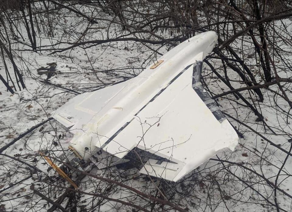
At around 13:00 local time (11:00 UTC) on September 14, 2026, a drone was recovered from the Baltic Sea on a beach at Rusinowo, near Jarosławiec, in Poland's Western Pomeranian Voivodeship. According to PAP, Deputy Prime Minister and Defense Minister Władysław Kosiniak-Kamysz said preliminary inspection pointed to a Russian military drone; RMF24 reported Kosiniak-Kamysz identifying it more specifically as a Russian Gerbera-type unmanned aircraft. AirVeto's wind-model data for the recovery window shows the conditions over the Sławno County coast at the time.
RMF24 reported that a Navy patrol boat crew spotted and recovered the aircraft during a routine patrol; Interia's account instead credits a passerby who found it on the beach and alerted authorities. Both outlets agree on the outcome: police, military engineers, and bomb-disposal specialists secured the site before the drone was moved for examination.
Officials point to a new Gerbera variant
Kosiniak-Kamysz told RMF24 that "increasing data suggests Russia probably lost a new type of Gerbera drone." Deputy Defense Minister Cezary Tomczyk went further: all indications point to Russian origin. Operational Command spokesman Jacek Goryszewski said the drone most likely drifted into Polish waters from international waters rather than crossing Polish airspace directly.
Most Gerbera airframes serve as radar decoys with no explosive payload, but some carry small warheads, which is why sappers were dispatched to assess the recovered unit before it was handled further. Interia reported no airspace violation had been detected in the area since July 31; this is a maritime drift recovery, not an intercepted incursion.
The third confirmed Gerbera recovery on Polish soil since September 2025
Rusinowo is the third Gerbera airframe Poland has confirmed since the September 9-10, 2025 mass drone incursion: a Gerbera was found in a field near Majdan Sielec three days before that incursion, and another turned up undetected for six months at a lignite mine near Gałczyce in March 2026. Rusinowo is the first of the three recovered from the Baltic Sea rather than found inland, and the first where Poland's own military, not a civilian worker, was first on the scene by at least one account.
Geographer Piotr Mickiewicz told Interia the stretch of coast near Jarosławiec carries added sensitivity: it hosts Polish military training grounds used for amphibious-landing exercises.
Wind over the Sławno County coast
At 11:00 UTC on September 14, the 1,000 m layer over the Sławno County coast showed wind pushing east at 11.4 km/h; at 2,000 m the flow pushed northeast at 19 km/h, and at 3,000 m it pushed southeast at 25.1 km/h. The drone came ashore by sea drift rather than by flight, so these figures describe the atmospheric conditions during the recovery window, not the drone's path to the coast. This reconstruction is based on Polish reporting on the recovery and on AirVeto's wind-model data for the recovery window.
Poland has now confirmed Gerbera airframes on its territory in three separate incidents spanning a full year, each recovered well after the drone came down rather than intercepted in flight. The full record of drone and airspace incidents over Polish territory is collected at Dron nad Polską.
Sources
- PAP - Szef MON: w rejonie miejscowości Rusinowo wojsko podjęło z morza drona, prawdopodobnie rosyjskiego (14 Sep 2026)
- RMF24 - Dron znaleziony w Bałtyku. Rosjanie prawdopodobnie utracili nowy model (14 Sep 2026)
- Interia - Dron na plaży koło Jarosławca. Kosiniak-Kamysz wskazuje na Rosję (14 Sep 2026)
- TVN24 - Dron w Bałtyku. Według szefa MON to wojskowy bezzałogowiec pochodzący z Rosji (14 Sep 2026)
- 15min.lt - Iš Baltijos jūros ištraukė droną. Lenkija nurodė, kam jis priklauso (14 Sep 2026)
- Methodology